Case Study
Dempsey Wood & Location Intelligence

Dempsey Wood’s Innovative Approach to Civil Contracting: Leveraging Location Intelligence for Sustainable Growth
Dempsey Wood, a well-established civil contractor in New Zealand, has showcased their innovative approach to civil contracting and sustainable growth through their collaboration with IMS Projects in leveraging Location Intelligence (LI).
IMS Projects LI team have developed three distinctive LI solutions for them: a land use planning application that visualises project locations, ecological areas, and land suitability; a Tender Dashboard that optimises project efficiency by reducing waste and transportation costs; and an editable LI application for future land development aligned with Auckland’s Growth Plans. These initiatives not only improve project outcomes but also underscore Dempsey Wood’s commitment to environmental stewardship and efficiency. As they continue to evolve, their pioneering use of Location Intelligence positions them as leaders in the field of civil engineering in New Zealand.
Abstract
Dempsey Wood, a family-owned and operated civil contractor established in 1993, has a rich history of delivering high-quality civil infrastructure projects and land development initiatives across the greater Auckland, Northland, and Waikato regions. With a dedicated workforce of over 500 personnel, Dempsey Wood is committed to excellence in service delivery and sustainable project outcomes. In collaboration with IMS Projects, Dempsey Wood has harnessed the power of Location Intelligence (LI) to enhance project planning, environmental stewardship, and cost efficiency. This case study explores three distinctive LI solutions implemented by Dempsey Wood, showcasing their commitment to innovation and sustainable growth.
1. Visualising Sustainable Land Use: Dempsey Wood Quarry Sites and More
In its quest for sustainable land use planning, Dempsey Wood partnered with IMS Projects to develop a cutting-edge Location Intelligence application. This application offers a comprehensive view of Dempsey Wood’s project locations, nearby places of interest such as quarry sites, cleanfills, landfills, as well as important geographic information from critical governmental authorities, including Auckland Council and Land Information New Zealand.


Key features of the application include:
· Visualising Auckland land parcels and their proximity to sensitive ecological areas (SEAs).
· Classifying land parcels into five categories based on their suitability for cleanfill, considering factors like accessibility, proximity to project sites, and not overpassing sensitive ecological areas in Auckland Unitary Plan.
· Ensuring potential land use by identifying parcels that are optimal for recycling sites, quarry sites, cleanfill, or landfills.
This LI application empowers Dempsey Wood to make informed decisions, identify best opportunities for directing and sourcing materials, and contribute to environmental conservation.
2. The Tender Dashboard: Streamlining Project Efficiency
Dempsey Wood understands the importance of efficiency and cost control in civil and earth works. To achieve this, they collaborated with IMS Projects to create the Tender Dashboard, a Location Intelligence tool that transforms project management.
Key highlights of the Tender Dashboard:
· Summarises Cut and Fill volumes for project sites, reducing waste and cost by optimising material use.
· Analyses waste and travel distance/time/costs, optimising project budgets.
· Enhances project management by reducing the need for offsite stockpiles and streamlining material transportation.
This dashboard underscores Dempsey Wood’s commitment to minimising environmental impact while maximising project efficiency and cost-effectiveness.
3. Future-Ready Land Development: An Editable Location Intelligence Application
As a forward-looking organisation, Dempsey Wood sought to understand the available land parcel areas within the context of Auckland’s growth plans for the next several decades. IMS Projects collaborated with Dempsey Wood to develop an editable and interactive Location Intelligence application for this purpose.
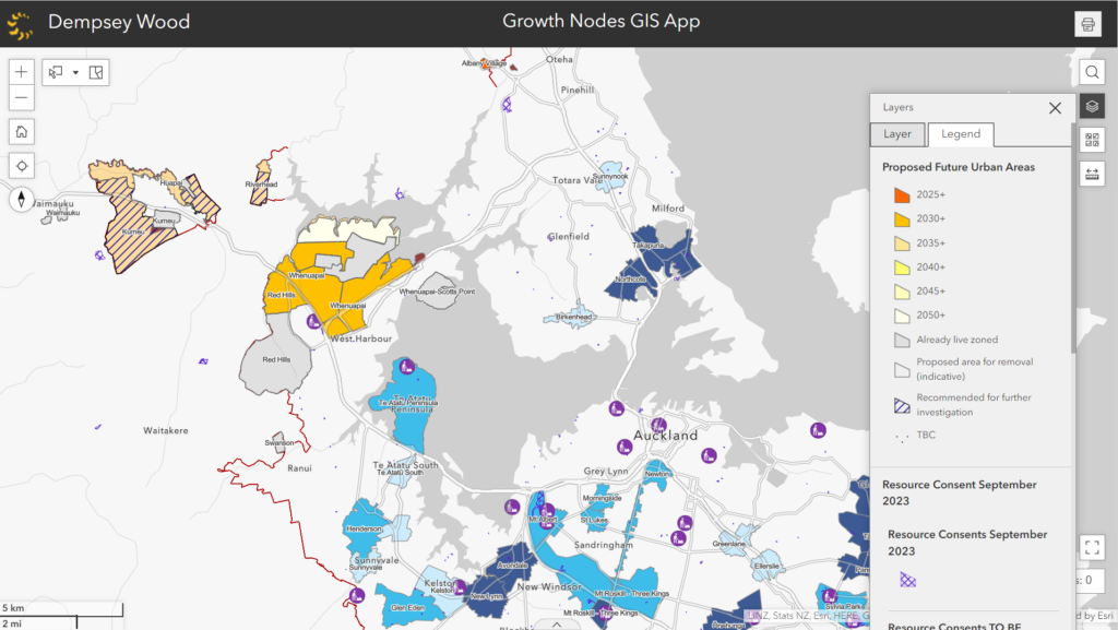
Key functionalities of this application include:
· Reviewing remaining undeveloped lands with potential for future projects.
· Utilising Auckland Council’s existing and proposed development plans, coupled with resource consent GIS data.
· Empowering Dempsey Wood’s managers to understand the layers of potential development areas in alignment with Auckland’s growth strategy.
· Enabling Dempsey Wood’s managers to edit and interact with potential lands priorities and potential to be developed in the next 5, 10, 20, 30 years.
By leveraging this innovative LI solution, Dempsey Wood positions itself as a leader in sustainable land development, aligning its projects with Auckland’s long-term vision.
Conclusion
Dempsey Wood’s commitment to delivering excellence in civil works is exemplified by its innovative use of Location Intelligence solutions.
Collaborating with IMS Projects, Dempsey Wood has harnessed LI applications to visualise land use, streamline project management, and plan for future growth. These initiatives not only enhance project outcomes but also reflect Dempsey Wood’s dedication to environmental stewardship, efficiency, and sustainable growth. As Dempsey Wood continues to evolve and expand, their pioneering approach to Location Intelligence will undoubtedly play a crucial role in shaping the future of civil engineering in New Zealand.
Interested? Check out our Data Insight Services or contact us directly at insights@ims-projects.co.nz